Search This Blog

Thursday, January 26, 2012

Rebellions, Revolutions, and Uprisings

What is a rebellion?  A revolution?  An uprising or an insurrection?

It is the refusal to be obedient or to follow or maintain order.  There have been many rebellions, revolutions, uprisings and insurrections even in your lifetime.  Even since your last birthday!  Can you think of one?


But this isn't the only rebellion in recent history.  Here are some more.


This was the Cultural Revolution in China.  China has had many rebellions - possibly the most famous was the student uprising in Tiannanmen Square.


Other uprisings you might have heard of have taken place in Egypt...


...This is part of what has been called the Arab Spring.


In the 60s, students in the US and around the world rose up against the war in Vietnam.


One of the most shocking and unbelievable moments for people of your parents' age was the fall of the Berlin wall.


Notes on Revolutions
A revolution (from the Latin revolutio, "a turn around") is a fundamental change in power or organizational structures that takes place in a relatively short period of time. 

There are several kinds of revolution:
•Political revolutions (American Revolution)
•Great revolutions which are sudden and violent and seek not only to establish a new political system but to transform an entire society (French and Russian Revolutions)
•Social revolutions which are slow but sweeping transformations of the entire society that take several generations to bring about (Agricultural and Industrial Revolutions)

CAUSES OF REVOLUTION
There are a number of things that can cause the kind of unrest that leads to revolution: 
  • poverty and a lack of power amongst the masses, 
  • discontent with the way things are
  • a desire to create change
  • a feeling of personal powerlessness 


Political Revolution (American Revolution)

•Britain imposed a series of arbitrary taxes on the colonists.
•The colonists had no vote in the British parliamentary system so they had no recourse when they were unhappy – they felt powerless.
•When the British dissolved local governments and sent troops, the colonists created their own militia to fight for their rights.  Fighting broke out in 1775.


Great Revolution (French Revolution)

The French Revolution (1789-1799) brought the end of the monarchy in just three years. These are the causes:
•There was widespread famine, malnutrition, disease and death amongst the peasantry.
• France was nearly bankrupt for two reasons – Louis XV had involved France directly in many wars and France had provided the Americans with support for their own Revolutionary War.
•France had lost many of its military battles and did not provide services for its veterans.
•The nobility continued to openly live lives of conspicuous consumption.
•The Catholic church began to tax crops.
•The cost of bread rose astronomically and many people were unemployed.
•The peasant class was angry and felt powerless to change things in a peaceful way.
The French Revolution did not just change the political situation in the country – it brought a complete political and social change including attitudes towards the peasantry and the role of women.  The cry of the French Revolution was “Liberté, égalité, fraternité”.  This represented a shocking (for the nobility) change in philosophy and attitude.


Social Revolution (Industrial Revolution)

The Industrial Revolution actually began with the Agricultural Revolution.  Both the Industrial and Agricultural Revolutions happened without war but we cannot say without bloodshed.  These revolutions were spurred on by discoveries made by explorers and scientists.  The changes began in Britain but spread throughout the world and the scientific and social changes have ramifications still today.

Regional Geography of North America

We will be learning about the geography (and therefore the history) of North America.  How can we be learning the geography and history at the same time?  Well, even land has history and North America is no exception.  


How was North America formed?  To answer that question, let's look at how all the continents were formed in this film The Early Earth and Plate Tectonics.


As you watch this clip, answer the following questions:


1.     Describe the make up of the earth.

2.     How are we protected from the cosmic wind put of by the sun?

3.     What are some of the unlikely neighbours that were created through the movement of continents? (find 3)

4.     Describe the movement of magma. 

5.     What can be found at the centre of the earth? 

6.     What does this heat and movement of magma create on the surface?


All the parts of Canada have changed over time.  This video clip - The Rise and Fall of the Great Lakes - shows how the Great Lakes changed.  The region that the Great Lakes fall in is called the Canadian Shield.  There are 8 physiographic regions in Canada.


Using the chart handout, fill in the information for each area:


Cordillera:

  • sometimes called the Western Mountains 
  • besides the mountains it also includes the Interior Plateau and the Yukon and Stikine Plateau.
  • found in British Columbia, the Yukon and partially into Alberta and the Northwest Territories.
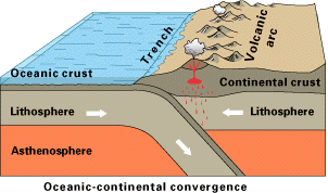
  • it was formed through Plate Tectonics when two plates collided and lifted one plate into the air.
  • sediments (pieces of earth, minerals) are washed down the rivers and leave rich river valleys like the Fraser Valley which is excellent for farming.
  • There are lots of minerals such as copper, gold, molybdenum, and coal.
Great Plains/Interior Plains:
  • this area stretches from the Western Mountains to the Canadian shield, covering most of Alberta, about half of Saskatchewan, about a quarter of Manitoba and part of the NWT.
  • the interior plains were formed by eroded material (bits of earth, rocks, minerals etc.) spreading out over the prairies in layers.  
  • Millions of years ago, the area was tropical (think Hawaii or Mexico) and was often flooded - this left bits of plants and dead animals.  
  • Over time the bits of dead animals and plants got squished into layers between the bits of earth and rock.
  • This made rich soil that is good for farming.
  • This also created fossil fuels like oil and natural gas and evaporites such as potash.


Canadian Shield:
  •  The Canadian Shield covers a small corner of Saskatchewan, most of Manitoba and the NWT, Nunavut, Ontario, Quebec and Labrador.
  • The Canadian Shied is made up of large masses of very hard rock which are the oldest parts of the earth.
  • the CS was once a volcanic mountain range as high as the Himalayas (Mount Everest).
  • Over millions of years weather and erosion has worn it down to a lot of exposed rock and lakes.
  • The CS is a storehouse of minerals including copper, gold, lead, and nickel.
  • The rockiness means the land is not good for farming.


Arctic Lowlands:
  • The AL lie in the upper middle parts of the NWT and Nunavut.
  • AL is also known as the Arctic Archipelago.
  • It consists of a series of islands that are made up of rock with a gently rolling landscape.
  • Because of the rock and the harsh climate, the AL is not suitable for farming.
  • It is rich in minerals such as lignite (a kind of coal), oil, natural gas, and limestone.

Innuitian Region:
  • This is the most northern part of Canada and is part of the Arctic Archipelago - specifically the Queen Elizabeth Islands.
  • The landscape is a series of mountains, plateaus, uplands and lowlands.
  • There are three mountain ranges: the Grantland, the Princess Margaret Range, and the Victoria and Albert Mountains.
  • The mountains are almost nearly covered in sheets of ice throughout the year and the rest is about 1/3 covered in ice all year.
  • This means that there is no ability to farm or mine in the region.


Great Lakes and Saint Lawrence Lowlands:
  • This area is along the southern edge of Quebec and parts of Ontario.
  • The Great Lakes cause hot and humid weather in the summer.
  • Generally the weather is mild, although the winters can be unpredictable - the humidity can make cold winters with sticky snow or frozen rain.
  • The rocks in this area hold many minerals including iron ore, zinc, silver, coal, copper and lead.
  • Scientists believe that this area was once a sea for along period of time. Layer after layer of sediment fell upon the sea floor. Once the sea began to dry up it left behind this very rich fertile soil which makes the St. Lawrence River area very good for farming.


Appalachian Region:
  • The Appalachian Region covers  New Brunswick, Nova Scotia, Prince Edward Island, Newfoundland and the eastern part of Quebec.
  • The landforms in the area are low rugged mountains, flat uplands, forests, rocky cliffs, and many islands.
  • the Grand Banks, which extends 400 kilometers off the east coast, is where the mixing of ocean currents created one of the richest fishing grounds in the world. 


Hudson Bay Lowlands:
  • This area runs along the southern shores of Hudson Bay and a very small section at the north.
  • It is a poorly drained piece of wetland with wide and slow moving rivers.
  • Population is low here for a number of reasons; lots of black flies and mosquitoes, heavy rainfall in the summer with wet & marshy lands, freezing temperatures and icy winds in the winter.


In groups of two to four, write the names of each region on a separate piece of paper and then spread them out face up on the desks between you.  You will see sixteen different pictures.  When you think you know which region the picture represents, slap your hand down on the correct piece of paper.  Be careful not to hurt each other!  The person with their hand on the correct region will get one point.  Only one hand on each piece of paper! There will be prizes!


One


Two


Three


Four


Five


Six


Seven


Eight


Nine


Ten


Eleven


Twelve


Thirteen


Fourteen


Fifteen


Sixteen


Using Culturegrams (found on the library page) you will make a powerpoint or Prezi describing one of the physiographic regions in Canada.  Your poster must include two pictures of each province - one of a rural area and one of an urban area; a map of each province; a graph comparing one aspect of the geography of each of the provinces; and one paragraph for each province including information on climate, geography, wildlife, environmental issues, and resources and industry.


Example:
Urban pictures...
Winnipeg, Manitoba's capital.
Edmonton, capital city of Alberta.
Vancouver on the west coast of Canada


Rural pictures....
Manitoba canola field
Alberta Hoodoos
BC in the Kootneys
Maps....
Manitoba landforms map
Alberta Landforms Map

British Columbia Landforms Map

Graphs....
This is due at the end of class, Feb. 14th (Happy Valentines Day!)

Canadian Flag


Where do these flags come from?  Try to guess.

ONE
TWO

THREE

FOUR


FIVE

SIX


What do you think each flag is?  What are the symbols on each flag?


These are all Canadian flags!


  1. The first flag is St. George's Cross and was placed on Canadian soil by John Cabot who claimed Canada for England.
  2. The second flag is the Fleur-de-lis which symbolized French sovereignty in Canada from 1534 when Jacques Cartier claimed the new world for France until the early 1760s.
  3. The third flag is the Royal Union Flag which was the British flag and the flag of the United Empire Loyalists.
  4. The fourth flag is the Union Jack - based on the Royal Union Flag, a diagonal red strip was added to represent Ireland.  This was used in Canada even after Confederation.
  5. The fifth flag is the Red Ensign.  This is a red flag with the Union Jack in the corner.  It was the flag of British Merchant Marine with parts of the provinces' coat of arms added on.
  6. The sixth flag is, of course, our Canadian flag today.  The red and white have long been used to represent France and England and were approved in 1921 by King George V.  In 1957, after playing with different coloured backgrounds and leaves, the red leaf on a white background with the two red bars at the side was agreed to.  The National Flag of Canada was approved by Parliament in 1964 and was proclaimed by Queen Elizabeth II to take effect on February 15th, 1965.  
 Look at each of the six flags.  Do these flags represent our country well?  How could they be improved?


Thinking about the Five Characteristics of Canadian Identity and the physiographic regions of Canada,  you are going to make a new flag for Canada.  What characteristics do you want to represent?  How are you going to symbolize them?  Write one paragraph telling what specifically your flag symbolizes.

This flag is due at the end of the block.

Wednesday, January 25, 2012

Geography=History=Economics=Politics=Environment


Why is it that we have a class called Social Studies?  Why don't we just study geography or history or economics or politics or the environment?  Well, it is difficult to study them individually because they are all intertwined.  Why should we study these topics?  It's important for us to understand the world around us.  Can you locate Canada on the world map?  Can you locate the US?  How about England or France or Iraq or China?  Why do you think some people cannot locate their own country on a world map?  While, certainly some of Miss South Carolina's answers came from nervousness, I would hate to see any of my students in a position where they cannot talk intelligently about the world they live in.

Let's see how much you know about the country and world we live in.  On the two maps on your hand out, fill in as many countries, provinces, and cities as you know.  You have 10 minutes to do this.


Watch the following video to find the answers to the questions below:


Social Studies 10
Why Geography?

1.     How many people are on earth?
2.     How much of the earth is covered by seas?
3.     How much of the earth is covered by desert?
4.     Earth is mostly ____________________________________ about 4000 miles deep.
5.     How thick is the earth’s crust?
6.     If the earth were an apple, how thick or thin would the crust be?
7.     85% of the atmosphere is only ________________________ miles thick.
8.     How old is the earth? 
9.     If you scale Earth’s existence to a day when did humankind arrive here?
10. List the 5 ways geography studies changes to people and the environment.
11. How quickly is global information increasing?
12. How many text messages are sent each day?
13. How many words are there in the English Language today?
14. How does this compare with Shakespeare’s time?
15. How much information does a week of The (New York) Times newspaper have compared to what would be available in the 18th century? 
16. What is the hierarchy of wisdom, knowledge, information and understanding?
17. What does GEO – GRAPHY  mean?
18. Geography allows you to think through what media? 


What is place? 


Geographers use 5 principles to help them understand the idea of place:
Places have a location.
Places have physical and cultural characteristics.
Places change over time.
Places interact with other places.
Places are in regions.

If I were to describe my home using these principles, I would say:
My home is in Duncan.
My home is on a hill with apple and walnut trees, and we practice aspects of Canadian, Italian, Japanese, and Welsh/Irish culture in our home.
My house has changed colour since I have lived there and now there is a road between the back of our yard and the farm behind us.  Also, we hear sheep now, rather than cows.
At our house, we will often cut part of the neighbour's grass on the north side and he will cut ours because we have no fence there.  We do the same for the farm on the other side of our house.
My home is in Duncan, on Vancouver Island.


Now, describe your home using these principles.