How was North America formed? To answer that question, let's look at how all the continents were formed in this film The Early Earth and Plate Tectonics.
As you watch this clip, answer the following questions:
1. Describe the make up of the earth.
2. How are we protected from the cosmic wind put of by the sun?
3. What are some of the unlikely neighbours that were created through the movement of continents? (find 3)
4. Describe the movement of magma.
5. What can be found at the centre of the earth?
6. What does this heat and movement of magma create on the surface?
All the parts of Canada have changed over time. This video clip - The Rise and Fall of the Great Lakes - shows how the Great Lakes changed. The region that the Great Lakes fall in is called the Canadian Shield. There are 8 physiographic regions in Canada.

Using the chart handout, fill in the information for each area:
Cordillera:

- sometimes called the Western Mountains
- besides the mountains it also includes the Interior Plateau and the Yukon and Stikine Plateau.
- found in British Columbia, the Yukon and partially into Alberta and the Northwest Territories.
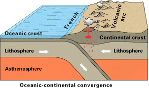
- it was formed through Plate Tectonics when two plates collided and lifted one plate into the air.
- sediments (pieces of earth, minerals) are washed down the rivers and leave rich river valleys like the Fraser Valley which is excellent for farming.
- There are lots of minerals such as copper, gold, molybdenum, and coal.
Great Plains/Interior Plains:
- this area stretches from the Western Mountains to the Canadian shield, covering most of Alberta, about half of Saskatchewan, about a quarter of Manitoba and part of the NWT.
- the interior plains were formed by eroded material (bits of earth, rocks, minerals etc.) spreading out over the prairies in layers.
- Millions of years ago, the area was tropical (think Hawaii or Mexico) and was often flooded - this left bits of plants and dead animals.
- Over time the bits of dead animals and plants got squished into layers between the bits of earth and rock.
- This made rich soil that is good for farming.
- This also created fossil fuels like oil and natural gas and evaporites such as potash.
Canadian Shield:
- The Canadian Shield covers a small corner of Saskatchewan, most of Manitoba and the NWT, Nunavut, Ontario, Quebec and Labrador.
- The Canadian Shied is made up of large masses of very hard rock which are the oldest parts of the earth.
- the CS was once a volcanic mountain range as high as the Himalayas (Mount Everest).
- Over millions of years weather and erosion has worn it down to a lot of exposed rock and lakes.
- The CS is a storehouse of minerals including copper, gold, lead, and nickel.
- The rockiness means the land is not good for farming.
Arctic Lowlands:
- The AL lie in the upper middle parts of the NWT and Nunavut.
- AL is also known as the Arctic Archipelago.
- It consists of a series of islands that are made up of rock with a gently rolling landscape.
- Because of the rock and the harsh climate, the AL is not suitable for farming.
- It is rich in minerals such as lignite (a kind of coal), oil, natural gas, and limestone.
Innuitian Region:
- This is the most northern part of Canada and is part of the Arctic Archipelago - specifically the Queen Elizabeth Islands.
- The landscape is a series of mountains, plateaus, uplands and lowlands.
- There are three mountain ranges: the Grantland, the Princess Margaret Range, and the Victoria and Albert Mountains.
- The mountains are almost nearly covered in sheets of ice throughout the year and the rest is about 1/3 covered in ice all year.
- This means that there is no ability to farm or mine in the region.
Great Lakes and Saint Lawrence Lowlands:
- This area is along the southern edge of Quebec and parts of Ontario.
- The Great Lakes cause hot and humid weather in the summer.
- Generally the weather is mild, although the winters can be unpredictable - the humidity can make cold winters with sticky snow or frozen rain.
- The rocks in this area hold many minerals including iron ore, zinc, silver, coal, copper and lead.
- Scientists believe that this area was once a sea for along period of time. Layer after layer of sediment fell upon the sea floor. Once the sea began to dry up it left behind this very rich fertile soil which makes the St. Lawrence River area very good for farming.
Appalachian Region:
- The Appalachian Region covers New Brunswick, Nova Scotia, Prince Edward Island, Newfoundland and the eastern part of Quebec.
- The landforms in the area are low rugged mountains, flat uplands, forests, rocky cliffs, and many islands.
- the Grand Banks, which extends 400 kilometers off the east coast, is where the mixing of ocean currents created one of the richest fishing grounds in the world.
Hudson Bay Lowlands:
- This area runs along the southern shores of Hudson Bay and a very small section at the north.
- It is a poorly drained piece of wetland with wide and slow moving rivers.
- Population is low here for a number of reasons; lots of black flies and mosquitoes, heavy rainfall in the summer with wet & marshy lands, freezing temperatures and icy winds in the winter.
In groups of two to four, write the names of each region on a separate piece of paper and then spread them out face up on the desks between you. You will see sixteen different pictures. When you think you know which region the picture represents, slap your hand down on the correct piece of paper. Be careful not to hurt each other! The person with their hand on the correct region will get one point. Only one hand on each piece of paper! There will be prizes!
 |
| One |
 |
| Two |
 |
| Three |
 |
| Four |
 |
| Five |
 |
| Six |
 |
| Seven |
 |
| Eight |
 |
| Nine |
 |
| Ten |
 |
| Eleven |
 |
| Twelve |
 |
| Thirteen |
 |
| Fourteen |
 |
| Fifteen |
 |
| Sixteen |
Using Culturegrams (found on the library page) you will make a powerpoint or Prezi describing one of the physiographic regions in Canada. Your poster must include two pictures of each province - one of a rural area and one of an urban area; a map of each province; a graph comparing one aspect of the geography of each of the provinces; and one paragraph for each province including information on climate, geography, wildlife, environmental issues, and resources and industry.
Example:
Urban pictures...
 |
| Winnipeg, Manitoba's capital. |
 |
| Edmonton, capital city of Alberta. |
 |
| Vancouver on the west coast of Canada |
Rural pictures....
 |
| Manitoba canola field |
 |
| Alberta Hoodoos |
 |
| BC in the Kootneys |
Maps....
 |
| Manitoba landforms map |
 |
| Alberta Landforms Map |
 |
| British Columbia Landforms Map |


